My assessment of this flight is without warranty as I am new at doing this but am a life long troubleshooter (Professionally) and Super R/C Geek for 20+ years who owns a few drones.
Just trying to help a brother out

First thing I see is A LOT of RED ink all over the log on Battery. At times I see you flying HARD as you should.....man that drone rips at one point going 68.0mph about 280 feet up

Anyways I preach to download and read your logs regularly as if I saw this I would bench cycle and test that battery under load. It recovered after you quit hitting it so hard.....I am sure it was fine after buy the readings.
So 2M & 34S into the flight you get the first signal Warning -
Image transmission signal weak. Adjust antennas and make sure they are perpendicular to flight direction of aircraft.
Right after that you let off the gas but the battery shows a lot of sag and voltage drop and 3 cells are red and 3 are orange. Might be an early indication this battery will provide shorter flight? Not sure but this is why I watch one flight from each battery per outing at least. but that is not your issue so moving on.
By 3M & 20S you are really getting up there. Not familiar with the area but we pilots love altitude so if anything that should have helped your signal. I did not realize in "Sport" mode you have no obstacle avoidance. Well see how that plays out at the end of the flight in terms of how high you are and if there are tress, buildings to run into during RTH, etc.
First Critical Low warring was 3M 34s and you were 3,672.9ft (About .7 miles from takeoff spot) This is why I watch my Batteries as if this was not expected at that time in the flight I would have hi tailed it home, but no guts no glory -
You are going 60 MPH after that so that battery is sagging bad under load, Very low on electrons at only 3M 45s into the flight? It was about 33%. Usually my % to land is 35%.
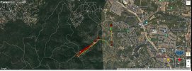
First loss of link occurred at 4M 2S and you were 5,796.5ft out at very high alt, (About 1 mile out) so you would think that is really a good setup - must have been low signal strength due to low battery?
The end of the flight is weird for me, this is where my lack of experience decoding these shows......you are barley on the left stick - and the bird is going like 50MPH? This area is 5M 19S into the flight Dunno as at that speed and height loosing input for 30 seconds? Wow....
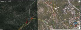
But we came back and the GPS shows the end of the flight on the map. That may help in your search. I have attached a screen shot or 2 from this story line..... and here is the Link to look at it on line. One of mine is zoomed in on google maps, likely the best your going to get without having an apple air tag on the drone (Which I want to try some day).
We have to assume the Battery is 100% dead so no beep from ESC and this bird may not be at ground level. There is a lot of trees around there and these props are like fingers hooking into the tree. Man drone in tree stories -there are a bunch of those. I even plowed a .40 size heli into a tree 20 feet up once. In that area consider your bird may be in the tress and may fall down days later due to wind.
Upload and view flight logs from your DJI drones

www.phantomhelp.com
I would think based on the shape of Ranch PKWY you could look right near that Bend in the road. That is where I would focus my efforts.
Good Luck - hope that helps in some way.......